![](/images/other/stat-length.png)
20220322-La Bouille
doudet
Benutzer
![Länge](/images/other/stat-length.png)
Länge
12,8 km
![Maximale Höhe](https://static1.geolcdn.com/siteimages/upload/files/1508320355ic_sort_altitude_max_24dp.png)
Maximale Höhe
135 m
![Positive Höhendifferenz](https://static1.geolcdn.com/siteimages/upload/files/1508320355ic_sort_den_pos_24dp.png)
Positive Höhendifferenz
228 m
![Km-Effort](/images/other/stat-length.png)
Km-Effort
15,8 km
![Min. Höhe](https://static1.geolcdn.com/siteimages/upload/files/1508320355ic_sort_altitude_min_24dp.png)
Min. Höhe
0 m
![Negative Höhendifferenz](https://static1.geolcdn.com/siteimages/upload/files/1508320355ic_sort_den_neg_24dp.png)
Negative Höhendifferenz
227 m
![Boucle](https://static1.geolcdn.com/siteimages/upload/files/16400158638029165_repeat_loop_refresh_sync_direction_icon.png)
Boucle
Ja
Erstellungsdatum :
2022-03-22 12:54:20.519
Letzte Änderung :
2022-03-23 07:24:57.833
![Wandern](https://static1.geolcdn.com/sitytour/trail-icons/101.png)
3h36
Schwierigkeit : Medium
![Scannen Sie diesen QR-Code, um die Tour in der SityTrail-Anwendung zu öffnen](https://capi.geolives.com/qq0zvz2zws4bq2lad0pu/sitytour/trails/3176777/qr.png?size=200)
Kostenlosegpshiking-Anwendung
Über SityTrail
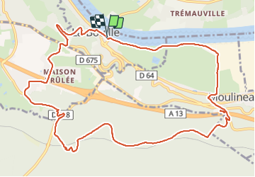
Tour Wandern von 12,8 km verfügbar auf Normandie, Seine-Maritime, La Bouille. Diese Tour wird von doudet vorgeschlagen.
Beschreibung
Boucle A-R au départ du Parking du Bac de La Bouille
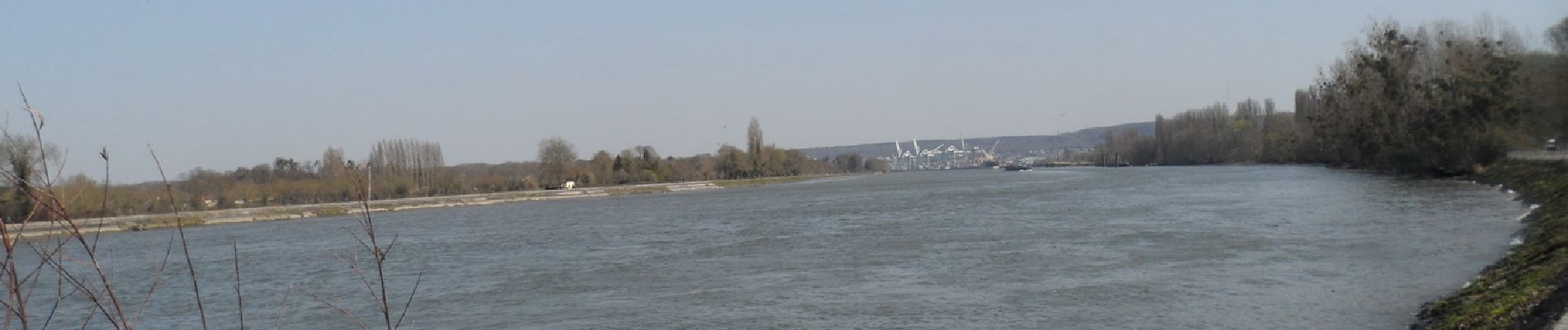
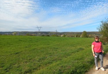
Ort
Land:
France
Region :
Normandie
Abteilung/Provinz :
Seine-Maritime
Kommune :
La Bouille
Standort:
Unknown
Gehen Sie:(Dec)
Gehen Sie:(UTM)
349889 ; 5468558 (31U) N.
Kommentare
Touren in der Umgebung
![Tour Wandern Hautot-sur-Seine - Hautot-sur-seine 11km - Photo](https://media.geolcdn.com/t/375/260/2e225eeb-e814-4a2c-a540-ca57c244afd9.jpg&format=jpg&maxdim=2)
![Wandern Wandern](https://static1.geolcdn.com/sitytour/trail-icons/101.png)
Hautot-sur-seine 11km
Wandern
Medium
(2)
Hautot-sur-Seine,
Normandie,
Seine-Maritime,
France
![](/images/other/stat-length.png)
11 km | 12,2 km-effort
2h 37min
![](https://static1.geolcdn.com/siteimages/upload/files/16400158638029165_repeat_loop_refresh_sync_direction_icon.png)
Ja
![Tour Wandern La Londe - La Londe 76- 13 km - Photo](https://media.geolcdn.com/t/375/260/23588b19-2689-475f-b2bd-10608cbf7253.jpg&format=jpg&maxdim=2)
![Wandern Wandern](https://static1.geolcdn.com/sitytour/trail-icons/101.png)
La Londe 76- 13 km
Wandern
Schwierig
(1)
La Londe,
Normandie,
Seine-Maritime,
France
![](/images/other/stat-length.png)
13 km | 16,1 km-effort
3h 43min
![](https://static1.geolcdn.com/siteimages/upload/files/16400158638029165_repeat_loop_refresh_sync_direction_icon.png)
Ja
![Tour Wandern Saint-Ouen-de-Thouberville - Saint-Ouen de Thouberville- Le Mesnil et la Pierre TTournante - Photo](https://media.geolcdn.com/t/375/260/f2450d67-38f3-46a5-aba6-c5e54414bed0.jpg&format=jpg&maxdim=2)
![Wandern Wandern](https://static1.geolcdn.com/sitytour/trail-icons/101.png)
Saint-Ouen de Thouberville- Le Mesnil et la Pierre TTournante
Wandern
Medium
(1)
Saint-Ouen-de-Thouberville,
Normandie,
Eure,
France
![](/images/other/stat-length.png)
12,5 km | 15,3 km-effort
3h 35min
![](https://static1.geolcdn.com/siteimages/upload/files/16400158638029165_repeat_loop_refresh_sync_direction_icon.png)
Ja
![Tour Wandern Moulineaux - Robert-le-Diable - château - GD - V2 - Photo](https://media.geolcdn.com/t/375/260/ext.jpg?maxdim=2&url=https%3A%2F%2Fstatic1.geolcdn.com%2Fsiteimages%2Fupload%2Ffiles%2F1553511878bg_sport_marche.png)
![Wandern Wandern](https://static1.geolcdn.com/sitytour/trail-icons/101.png)
Robert-le-Diable - château - GD - V2
Wandern
Schwierig
(1)
Moulineaux,
Normandie,
Seine-Maritime,
France
![](/images/other/stat-length.png)
10,4 km | 13,1 km-effort
2h 58min
![](https://static1.geolcdn.com/siteimages/upload/files/16400158638029165_repeat_loop_refresh_sync_direction_icon.png)
Ja
![Tour Zu Fuß Saint-Pierre-de-Manneville - Du coté du Manoir de Villers - Photo](https://media.geolcdn.com/t/375/260/ext.jpg?maxdim=2&url=https%3A%2F%2Fstatic1.geolcdn.com%2Fsiteimages%2Fupload%2Ffiles%2F1545311037marcheuse_200dpi.jpg)
![Zu Fuß Zu Fuß](https://static1.geolcdn.com/sitytour/trail-icons/100.png)
Du coté du Manoir de Villers
Zu Fuß
Einfach
(1)
Saint-Pierre-de-Manneville,
Normandie,
Seine-Maritime,
France
![](/images/other/stat-length.png)
11 km | 12,5 km-effort
2h 45min
![](https://static1.geolcdn.com/siteimages/upload/files/16400158638029165_repeat_loop_refresh_sync_direction_icon.png)
Ja
![Tour Wandern Saint-Pierre-de-Manneville - Les manoirs - Photo](https://media.geolcdn.com/t/375/260/ext.jpg?maxdim=2&url=https%3A%2F%2Fstatic1.geolcdn.com%2Fsiteimages%2Fupload%2Ffiles%2F1553511878bg_sport_marche.png)
![Wandern Wandern](https://static1.geolcdn.com/sitytour/trail-icons/101.png)
Les manoirs
Wandern
Schwierig
(1)
Saint-Pierre-de-Manneville,
Normandie,
Seine-Maritime,
France
![](/images/other/stat-length.png)
13,8 km | 15,5 km-effort
3h 31min
![](https://static1.geolcdn.com/siteimages/upload/files/16400158638029165_repeat_loop_refresh_sync_direction_icon.png)
Ja
![Wandern Wandern](https://static1.geolcdn.com/sitytour/trail-icons/101.png)
20240507-La Londe Cool
Wandern
Einfach
La Londe,
Normandie,
Seine-Maritime,
France
![](/images/other/stat-length.png)
7,3 km | 9,2 km-effort
2h 15min
![](https://static1.geolcdn.com/siteimages/upload/files/16400158638029165_repeat_loop_refresh_sync_direction_icon.png)
Ja
![Tour Wandern Saint-Pierre-de-Manneville - st pierre de mainneville - Photo](https://media.geolcdn.com/t/375/260/d707c7b4-7da5-46fa-aedb-46579dbd0e82.jpg&format=jpg&maxdim=2)
![Wandern Wandern](https://static1.geolcdn.com/sitytour/trail-icons/101.png)
st pierre de mainneville
Wandern
Medium
Saint-Pierre-de-Manneville,
Normandie,
Seine-Maritime,
France
![](/images/other/stat-length.png)
7,6 km | 8,9 km-effort
1h 25min
![](https://static1.geolcdn.com/siteimages/upload/files/16400158638029165_repeat_loop_refresh_sync_direction_icon.png)
Ja
![Wandern Wandern](https://static1.geolcdn.com/sitytour/trail-icons/101.png)
la londe
Wandern
Schwierig
La Londe,
Normandie,
Seine-Maritime,
France
![](/images/other/stat-length.png)
11,6 km | 14,3 km-effort
3h 14min
![](https://static1.geolcdn.com/siteimages/upload/files/16400158638029165_repeat_loop_refresh_sync_direction_icon.png)
Nein